
Earth’s crust is made up of large fractured plates that have moved very slowly over the Earth’s surface for millions of years. In western California, two of these plates meet and form the San Andreas Fault, one of the longest continuous fault lines in the world.
The Pacific Plate is slowly moving northwest past the North American Plate. This movement causes pressure to build up along the fault, which is released as earthquakes. Measurements show the plates can shift as much as 2 inches per year. The San Andreas Fault system is more than 800 miles long and extends about 10 miles deep. In San Bernardino County, the San Andreas Fault runs through Wrightwood, Highland and the edge of the San Bernardino Mountains.
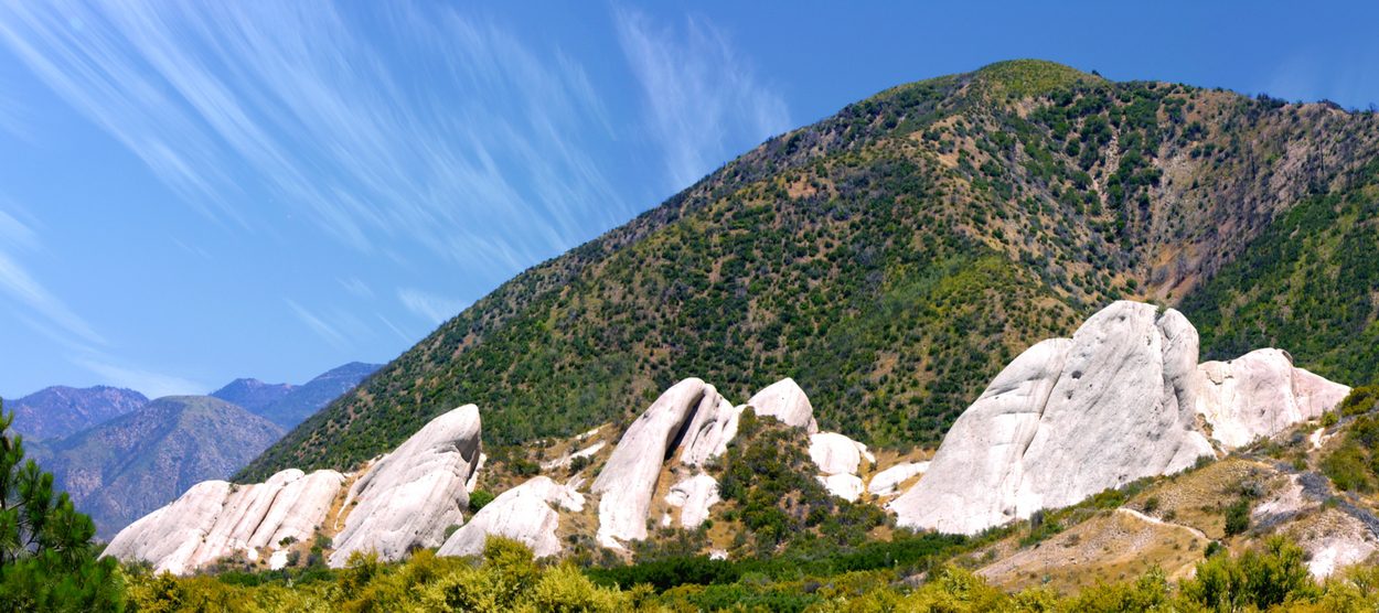
One of the most visible features linked to the fault is the Mormon Rocks in Cajon Pass. Farther southeast, other related faults, including the San Jacinto and Banning faults, share similar movements of the crustal plates.
Historically, the San Andreas Fault has produced major earthquakes. The 1857 Fort Tejon earthquake was estimated at magnitude 7.9 and was felt across much of California and as far as Las Vegas, Nevada. The 1906 earthquake in the San Francisco area was estimated at a magnitude 7.7 to 7.9. It caused roads, fences and rows of trees that crossed the fault to be offset by as much as 21 feet and was felt as far away as Oregon and central Nevada.
Geologic studies show that over the past 1,400 to 1,500 years, large earthquakes have occurred on the southern San Andreas Fault roughly every 150 years. One of the last major events in the southern section was the 1857 earthquake, which is a likely location for another very large earthquake, according to the U.S. Geological Survey.
In San Bernardino County, the largest recorded earthquake was the 1992 Landers earthquake, which was a magnitude 7.3 earthquake that lasted more than two minutes and was felt as far away as Mexico. It was followed hours later by a magnitude 6.5 earthquake in Big Bear. Neither earthquake occurred directly on the San Andreas Fault, but both happened nearby.
The information in this historical feature was originally part of a video series produced by the Assessor-Recorder-County Clerk’s office.
Additional County Update News – June 18, 2026
- A new tool for firefighter safety: Introducing our robot dog
- Preschool Services marks 61 years of Head Start – Building bright futures for children and families
- San Bernardino County Board of Supervisors approves landmark Behavioral Health Services Act 2026–2029 Integrated Plan
- Medi-Cal changes set to roll out beginning Oct. 1
- SPARK Youth Employment Program underway
- Public Health launches new interactive opioid StoryMap to advance data-driven solutions
- Pets are family. Make sure they’re part of your emergency plan.
- County shelters celebrate 26 adoptions during California Adopt-A-Pet Day
- Hundreds gather at Lake Gregory for First 5 San Bernardino water safety event
- County offices holiday closure
- Submit your Route 66 photos for a chance to win a San Bernardino County Regional Parks or Big Bear Alpine Zoo annual pass
- SBC Through Your Eyes: Little Charlton Peak
- Submit your photos and videos of the county’s destinations, nature and cityscapes
- Things to do in San Bernardino County
- Pet of the Week: Twix